2
More Annotations


3
4
Favourite Annotations


4


5
Text
HOME - RAPTOR MAPSTECHNOLOGYINDUSTRY SOLUTIONSPARTNERSRESOURCESABOUTCONTACT US Raptor Maps makes it simple and affordable for solar companies to adopt drone technology as a tool to increase performance, reduce costs, and standardize & compare solar PV assets across a portfolio. We work with portfolio owners, asset managers, O&M providers, RESOURCES - RAPTOR MAPS Software company reveals record-high collaboration between users in annual benchmarking report Above is a first-of-its-kind industry network graph illustrating the collaboration between users in the Raptor Maps software on a subset of data.
DELIVERABLES
Begin Optimizing! Start increasing your energy production and reducing costs with Raptor Maps’ detailed PV deliverables. We support Asset Owners, EPCs, Asset Management, and O&M teams looking to benefit from monitoring their solar assets with aerial thermography. Click the button below to get started with Raptor Maps. SCHEDULE A DEMO.JOBS - RAPTOR MAPS
Raptor Maps makes it simple and affordable for solar companies to adopt drone technology as a tool to increase performance, reduce costs, and standardize & compare solar PV assets across a portfolio. We work with portfolio owners, asset managers, O&M providers,RAPTOR MAPS
Raptor Maps Use Cases. Types of Inspections and Uses. Reviewing Anomalies. Solar Site Maintenance. Management Decision Making. Supporting Warranty Claims. Temperature Delta Calculations. Reviewing Aggregate and Benchmarking Data. Raptor Records.FAQ - RAPTOR MAPS
Raptor Maps makes it simple and affordable for solar companies to adopt drone technology as a tool to increase performance, reduce costs, and standardize & compare solar PV assets across a portfolio. We work with portfolio owners, asset managers, O&M providers, SOLAR SITE MAINTENANCE Solar Site Maintenance. Use Raptor Maps to identify and locate solar site maintenance issues. Specifically, the app enables maintenance crews to: Review a list of defects identified during a solar site inspection. Prioritize each anomaly, enabling the most serious issues to be addressed first. Find the defective components on the ground sothat
ACCESSING THE RAPTOR APP Accessing the Raptor App. This page will help you get started with Raptor Maps. Suggest Edits. The Raptor App is located at https://app.raptormaps.com. Simply head to that address in your browser's URL bar. For optimal performance, Google Chrome isrecommended.
9 QUESTIONS TO ASK A DRONE SERVICE PROVIDER BEFORE YOU To ensure you’re getting the most value from each inspection, you should qualify the drone service provider before hiring them. We recommend asking the following 9 questions before determining who to choose as your DSP: 1. How much experience do you have in aerial inspections of solar PV systems? We recommend requesting flight logsfrom the DSP.
O&M FLIGHT GUIDELINES The O&M Data Requirements can be met with various drones, camera payloads, and flight mission planning software. The most popular drone platforms that support thermal cameras are the DJI M200 series and Sensefly Ebee. Other drones include the DJI Inspire 1, Intel Falcon, and the Aeryon SkyRanger. HOME - RAPTOR MAPSTECHNOLOGYINDUSTRY SOLUTIONSPARTNERSRESOURCESABOUTCONTACT US Raptor Maps makes it simple and affordable for solar companies to adopt drone technology as a tool to increase performance, reduce costs, and standardize & compare solar PV assets across a portfolio. We work with portfolio owners, asset managers, O&M providers, RESOURCES - RAPTOR MAPS Software company reveals record-high collaboration between users in annual benchmarking report Above is a first-of-its-kind industry network graph illustrating the collaboration between users in the Raptor Maps software on a subset of data.DELIVERABLES
Begin Optimizing! Start increasing your energy production and reducing costs with Raptor Maps’ detailed PV deliverables. We support Asset Owners, EPCs, Asset Management, and O&M teams looking to benefit from monitoring their solar assets with aerial thermography. Click the button below to get started with Raptor Maps. SCHEDULE A DEMO.JOBS - RAPTOR MAPS
Raptor Maps makes it simple and affordable for solar companies to adopt drone technology as a tool to increase performance, reduce costs, and standardize & compare solar PV assets across a portfolio. We work with portfolio owners, asset managers, O&M providers,RAPTOR MAPS
Raptor Maps Use Cases. Types of Inspections and Uses. Reviewing Anomalies. Solar Site Maintenance. Management Decision Making. Supporting Warranty Claims. Temperature Delta Calculations. Reviewing Aggregate and Benchmarking Data. Raptor Records.FAQ - RAPTOR MAPS
Raptor Maps makes it simple and affordable for solar companies to adopt drone technology as a tool to increase performance, reduce costs, and standardize & compare solar PV assets across a portfolio. We work with portfolio owners, asset managers, O&M providers, SOLAR SITE MAINTENANCE Solar Site Maintenance. Use Raptor Maps to identify and locate solar site maintenance issues. Specifically, the app enables maintenance crews to: Review a list of defects identified during a solar site inspection. Prioritize each anomaly, enabling the most serious issues to be addressed first. Find the defective components on the ground sothat
ACCESSING THE RAPTOR APP Accessing the Raptor App. This page will help you get started with Raptor Maps. Suggest Edits. The Raptor App is located at https://app.raptormaps.com. Simply head to that address in your browser's URL bar. For optimal performance, Google Chrome isrecommended.
9 QUESTIONS TO ASK A DRONE SERVICE PROVIDER BEFORE YOU To ensure you’re getting the most value from each inspection, you should qualify the drone service provider before hiring them. We recommend asking the following 9 questions before determining who to choose as your DSP: 1. How much experience do you have in aerial inspections of solar PV systems? We recommend requesting flight logsfrom the DSP.
O&M FLIGHT GUIDELINES The O&M Data Requirements can be met with various drones, camera payloads, and flight mission planning software. The most popular drone platforms that support thermal cameras are the DJI M200 series and Sensefly Ebee. Other drones include the DJI Inspire 1, Intel Falcon, and the Aeryon SkyRanger.ABOUT - RAPTOR MAPS
Raptor Maps makes it simple and affordable for solar companies to adopt drone technology as a tool to increase performance, reduce costs, and standardize & compare solar PV assets across a portfolio. We work with portfolio owners, asset managers, O&M providers, RAPTOR MAPS INDUSTRY SOLUTIONS Raptor Maps provides software solutions and data to optimize solar assets from inception and design, through construction, commissioning,and operating life.
TECHNOLOGY - RAPTOR MAPS Raptor Maps makes it simple and affordable for solar companies to adopt drone technology as a tool to increase performance, reduce costs, and standardize & compare solar PV assets across a portfolio. We work with portfolio owners, asset managers, O&M providers,RAPTOR MAPS
Raptor Maps Use Cases. Types of Inspections and Uses. Reviewing Anomalies. Solar Site Maintenance. Management Decision Making. Supporting Warranty Claims. Temperature Delta Calculations. Reviewing Aggregate and Benchmarking Data. Raptor Records.PROOF POINTS
The inspection took half a day to complete, including setup, flights, and packing up. The drone inspection discovered 1.78% of the site’s energy production was affected. A total of 165 anomalies were identified, with 607 modules being impacted. This high number of PV system anomalies was estimated to lead to an annual loss of $14,836. THERMAL INSPECTION AND ANALYTICS Raptor Maps provides software to the solar industry that enables the adoption of aerial thermography for efficient inspections and analytics. Our software solution reviews and processes thermal images taken of the solar PV system and then identifies, classifies, and prioritizes 100% of all anomalies. SOLAR SITE MAINTENANCE Solar Site Maintenance. Use Raptor Maps to identify and locate solar site maintenance issues. Specifically, the app enables maintenance crews to: Review a list of defects identified during a solar site inspection. Prioritize each anomaly, enabling the most serious issues to be addressed first. Find the defective components on the ground sothat
INTRODUCTION TO AERIAL THERMOGRAPHY: OVERVIEW AERIAL Overview Level The following series breaks down the three most common levels of aerial thermography inspections used by Raptor Maps to identify defects, faults, and anomalies affecting PV system performance. The inspections; Overview, Standard, and Comprehensive, differ in flight altitude, data capture time, level of analysis, and the level of detail in the final deliverables. HOW TO INSPECT SOLAR FARMS WITH DRONES The solar industry is growing exponentially. There are now over 300 GW of capacity in the world 1, including 47 GW in the United States 2.Operations and maintenance (O&M) providers are responsible for the upkeep of large photovoltaic systems (solar farms), and they are increasingly turning to drones to reduce maintenance costs and increase power generation.SHADING ANALYSIS
Shading analysis provides teams with an efficient means to assess the impact of perimeter shading on solar sites. Use this turnkey service from Raptor Maps to: For O&M organizations, refine performance forecasting based on analysis of onsite shading. For EPC groups, leverage findings to improve construction practices for future sites. RESOURCES - RAPTOR MAPS An Introduction to the Portfolio Case Study. Apr 23, 2020 | Inspection, News. Raptor Maps recently released a case study that reports on five heavily impacted sites owned and managed by a large, U.S.-based asset owner. The owner’s solar portfolio totals more than410 MW of
DELIVERABLES
Begin Optimizing! Start increasing your energy production and reducing costs with Raptor Maps’ detailed PV deliverables. We support Asset Owners, EPCs, Asset Management, and O&M teams looking to benefit from monitoring their solar assets with aerial thermography. Click the button below to get started with Raptor Maps. SCHEDULE A DEMO.ABOUT - RAPTOR MAPS
Raptor Maps makes it simple and affordable for solar companies to adopt drone technology as a tool to increase performance, reduce costs, and standardize & compare solar PV assets across a portfolio. We work with portfolio owners, asset managers, O&M providers,JOBS - RAPTOR MAPS
Solar power is the #1 source of new energy in the world. Raptor Maps is a fast-growing, MIT-born startup that builds software to manage the solar lifecycle. We are deployed across 38 countries and 70 million solar panels. Our software enables the solar industry to scale. We are looking for software engineers, customer support, salespeople, dataRAPTOR MAPS
Raptor Maps Use Cases. Types of Inspections and Uses. Reviewing Anomalies. Solar Site Maintenance. Management Decision Making. Supporting Warranty Claims. Temperature Delta Calculations. Reviewing Aggregate and Benchmarking Data. Raptor Records.FAQ - RAPTOR MAPS
Raptor Maps makes it simple and affordable for solar companies to adopt drone technology as a tool to increase performance, reduce costs, and standardize & compare solar PV assets across a portfolio. We work with portfolio owners, asset managers, O&M providers, SOLAR SITE MAINTENANCE Solar Site Maintenance. Use Raptor Maps to identify and locate solar site maintenance issues. Specifically, the app enables maintenance crews to: Review a list of defects identified during a solar site inspection. Prioritize each anomaly, enabling the most serious issues to be addressed first. Find the defective components on the ground sothat
ACCESSING THE RAPTOR APP Accessing the Raptor App. This page will help you get started with Raptor Maps. Suggest Edits. The Raptor App is located at https://app.raptormaps.com. Simply head to that address in your browser's URL bar. For optimal performance, Google Chrome isrecommended.
9 QUESTIONS TO ASK A DRONE SERVICE PROVIDER BEFORE YOU To ensure you’re getting the most value from each inspection, you should qualify the drone service provider before hiring them. We recommend asking the following 9 questions before determining who to choose as your DSP: 1. How much experience do you have in aerial inspections of solar PV systems? We recommend requesting flight logsfrom the DSP.
O&M FLIGHT GUIDELINES The O&M Data Requirements can be met with various drones, camera payloads, and flight mission planning software. The most popular drone platforms that support thermal cameras are the DJI M200 series and Sensefly Ebee. Other drones include the DJI Inspire 1, Intel Falcon, and the Aeryon SkyRanger. HOME - RAPTOR MAPSTECHNOLOGYINDUSTRY SOLUTIONSPARTNERSRESOURCESABOUTCONTACT US Raptor Maps makes it simple and affordable for solar companies to adopt drone technology as a tool to increase performance, reduce costs, and standardize & compare solar PV assets across a portfolio. We work with portfolio owners, asset managers, O&M providers, RESOURCES - RAPTOR MAPS Software company reveals record-high collaboration between users in annual benchmarking report Above is a first-of-its-kind industry network graph illustrating the collaboration between users in the Raptor Maps software on a subset of data.DELIVERABLES
Begin Optimizing! Start increasing your energy production and reducing costs with Raptor Maps’ detailed PV deliverables. We support Asset Owners, EPCs, Asset Management, and O&M teams looking to benefit from monitoring their solar assets with aerial thermography. Click the button below to get started with Raptor Maps. SCHEDULE A DEMO.JOBS - RAPTOR MAPS
Raptor Maps makes it simple and affordable for solar companies to adopt drone technology as a tool to increase performance, reduce costs, and standardize & compare solar PV assets across a portfolio. We work with portfolio owners, asset managers, O&M providers,RAPTOR MAPS
Raptor Maps Use Cases. Types of Inspections and Uses. Reviewing Anomalies. Solar Site Maintenance. Management Decision Making. Supporting Warranty Claims. Temperature Delta Calculations. Reviewing Aggregate and Benchmarking Data. Raptor Records.FAQ - RAPTOR MAPS
Raptor Maps makes it simple and affordable for solar companies to adopt drone technology as a tool to increase performance, reduce costs, and standardize & compare solar PV assets across a portfolio. We work with portfolio owners, asset managers, O&M providers, SOLAR SITE MAINTENANCE Solar Site Maintenance. Use Raptor Maps to identify and locate solar site maintenance issues. Specifically, the app enables maintenance crews to: Review a list of defects identified during a solar site inspection. Prioritize each anomaly, enabling the most serious issues to be addressed first. Find the defective components on the ground sothat
ACCESSING THE RAPTOR APP Accessing the Raptor App. This page will help you get started with Raptor Maps. Suggest Edits. The Raptor App is located at https://app.raptormaps.com. Simply head to that address in your browser's URL bar. For optimal performance, Google Chrome isrecommended.
9 QUESTIONS TO ASK A DRONE SERVICE PROVIDER BEFORE YOU To ensure you’re getting the most value from each inspection, you should qualify the drone service provider before hiring them. We recommend asking the following 9 questions before determining who to choose as your DSP: 1. How much experience do you have in aerial inspections of solar PV systems? We recommend requesting flight logsfrom the DSP.
O&M FLIGHT GUIDELINES The O&M Data Requirements can be met with various drones, camera payloads, and flight mission planning software. The most popular drone platforms that support thermal cameras are the DJI M200 series and Sensefly Ebee. Other drones include the DJI Inspire 1, Intel Falcon, and the Aeryon SkyRanger.ABOUT - RAPTOR MAPS
Raptor Maps makes it simple and affordable for solar companies to adopt drone technology as a tool to increase performance, reduce costs, and standardize & compare solar PV assets across a portfolio. We work with portfolio owners, asset managers, O&M providers, RAPTOR MAPS INDUSTRY SOLUTIONS Raptor Maps provides software solutions and data to optimize solar assets from inception and design, through construction, commissioning,and operating life.
TECHNOLOGY - RAPTOR MAPS Raptor Maps makes it simple and affordable for solar companies to adopt drone technology as a tool to increase performance, reduce costs, and standardize & compare solar PV assets across a portfolio. We work with portfolio owners, asset managers, O&M providers,RAPTOR MAPS
Raptor Maps Use Cases. Types of Inspections and Uses. Reviewing Anomalies. Solar Site Maintenance. Management Decision Making. Supporting Warranty Claims. Temperature Delta Calculations. Reviewing Aggregate and Benchmarking Data. Raptor Records.PROOF POINTS
The inspection took half a day to complete, including setup, flights, and packing up. The drone inspection discovered 1.78% of the site’s energy production was affected. A total of 165 anomalies were identified, with 607 modules being impacted. This high number of PV system anomalies was estimated to lead to an annual loss of $14,836. SOLAR SITE MAINTENANCE Solar Site Maintenance. Use Raptor Maps to identify and locate solar site maintenance issues. Specifically, the app enables maintenance crews to: Review a list of defects identified during a solar site inspection. Prioritize each anomaly, enabling the most serious issues to be addressed first. Find the defective components on the ground sothat
INTRODUCTION TO AERIAL THERMOGRAPHY: OVERVIEW AERIAL Overview Level The following series breaks down the three most common levels of aerial thermography inspections used by Raptor Maps to identify defects, faults, and anomalies affecting PV system performance. The inspections; Overview, Standard, and Comprehensive, differ in flight altitude, data capture time, level of analysis, and the level of detail in the final deliverables. 10 MOST COMMON PV SYSTEM ANOMALIES DETECTED BY DRONES … Shattering (cracked glass) of panels due to module installation, maintenance, racking shifts, or severe weather is an anomaly that can be easily detected with RGB imagery. Soiling from dust, bird droppings, and other debris can also heavily affect the efficiency of PV modules. 4. String Level Issues. String issues are the most severe(and
HOW TO INSPECT SOLAR FARMS WITH DRONES The solar industry is growing exponentially. There are now over 300 GW of capacity in the world 1, including 47 GW in the United States 2.Operations and maintenance (O&M) providers are responsible for the upkeep of large photovoltaic systems (solar farms), and they are increasingly turning to drones to reduce maintenance costs and increase power generation.SHADING ANALYSIS
Shading analysis provides teams with an efficient means to assess the impact of perimeter shading on solar sites. Use this turnkey service from Raptor Maps to: For O&M organizations, refine performance forecasting based on analysis of onsite shading For EPC groups, leverage findings to improve HOME - RAPTOR MAPSTECHNOLOGYINDUSTRY SOLUTIONSPARTNERSRESOURCESABOUTCONTACT US Raptor Maps makes it simple and affordable for solar companies to adopt drone technology as a tool to increase performance, reduce costs, and standardize & compare solar PV assets across a portfolio. We work with portfolio owners, asset managers, O&M providers,JOBS - RAPTOR MAPS
Solar power is the #1 source of new energy in the world. Raptor Maps is a fast-growing, MIT-born startup that builds software to manage the solar lifecycle. We are deployed across 38 countries and 70 million solar panels. Our software enables the solar industry to scale. We are looking for software engineers, customer support, salespeople, dataFAQ - RAPTOR MAPS
Raptor Maps makes it simple and affordable for solar companies to adopt drone technology as a tool to increase performance, reduce costs, and standardize & compare solar PV assets across a portfolio. We work with portfolio owners, asset managers, O&M providers, SOLAR SITE MAINTENANCE Solar Site Maintenance. Use Raptor Maps to identify and locate solar site maintenance issues. Specifically, the app enables maintenance crews to: Review a list of defects identified during a solar site inspection. Prioritize each anomaly, enabling the most serious issues to be addressed first. Find the defective components on the ground sothat
INTRODUCTION TO AERIAL THERMOGRAPHY: COMPREHENSIVE AERIAL Comprehensive Level The following series breaks down the three most common levels of aerial thermography inspections used by Raptor Maps to identify defects, faults, and anomalies affecting PV system performance. The inspections; Overview, Standard, and Comprehensive, differ in flight altitude, data capture time, level of analysis, and the level of detail in the final deliverables. ACCESSING THE RAPTOR APP Accessing the Raptor App. This page will help you get started with Raptor Maps. Suggest Edits. The Raptor App is located at https://app.raptormaps.com. Simply head to that address in your browser's URL bar. For optimal performance, Google Chrome isrecommended.
FLIGHT GUIDELINES FOR ROOFTOP MODELING Rooftop modeling requires two flights: a mapping flight and 1-2 orbital flights. The two types of flights are as follows: Rooftop Modeling Flight Obstruction Heights Rooftop Modeling Flight Equipment Drone: Capture images with a multi-copter UAS with gimbal mounted camera. A DJI Phantom 4 Pro is the 9 QUESTIONS TO ASK A DRONE SERVICE PROVIDER BEFORE YOU To ensure you’re getting the most value from each inspection, you should qualify the drone service provider before hiring them. We recommend asking the following 9 questions before determining who to choose as your DSP: 1. How much experience do you have in aerial inspections of solar PV systems? We recommend requesting flight logsfrom the DSP.
DRONES: SHADING & ROOFTOP CAD Compatible Hardware Images must be JPEG and contain metadata (GPS, relative altitude, gimbal altitude, and timestamp) O&M FLIGHT GUIDELINES The O&M Data Requirements can be met with various drones, camera payloads, and flight mission planning software. The most popular drone platforms that support thermal cameras are the DJI M200 series and Sensefly Ebee. Other drones include the DJI Inspire 1, Intel Falcon, and the Aeryon SkyRanger. HOME - RAPTOR MAPSTECHNOLOGYINDUSTRY SOLUTIONSPARTNERSRESOURCESABOUTCONTACT US Raptor Maps makes it simple and affordable for solar companies to adopt drone technology as a tool to increase performance, reduce costs, and standardize & compare solar PV assets across a portfolio. We work with portfolio owners, asset managers, O&M providers,JOBS - RAPTOR MAPS
Raptor Maps makes it simple and affordable for solar companies to adopt drone technology as a tool to increase performance, reduce costs, and standardize & compare solar PV assets across a portfolio. We work with portfolio owners, asset managers, O&M providers,FAQ - RAPTOR MAPS
Raptor Maps makes it simple and affordable for solar companies to adopt drone technology as a tool to increase performance, reduce costs, and standardize & compare solar PV assets across a portfolio. We work with portfolio owners, asset managers, O&M providers, SOLAR SITE MAINTENANCE Solar Site Maintenance. Use Raptor Maps to identify and locate solar site maintenance issues. Specifically, the app enables maintenance crews to: Review a list of defects identified during a solar site inspection. Prioritize each anomaly, enabling the most serious issues to be addressed first. Find the defective components on the ground sothat
INTRODUCTION TO AERIAL THERMOGRAPHY: COMPREHENSIVE AERIAL Comprehensive Level The following series breaks down the three most common levels of aerial thermography inspections used by Raptor Maps to identify defects, faults, and anomalies affecting PV system performance. The inspections; Overview, Standard, and Comprehensive, differ in flight altitude, data capture time, level of analysis, and the level of detail in the final deliverables. ACCESSING THE RAPTOR APP Accessing the Raptor App. This page will help you get started with Raptor Maps. Suggest Edits. The Raptor App is located at https://app.raptormaps.com. Simply head to that address in your browser's URL bar. For optimal performance, Google Chrome isrecommended.
FLIGHT GUIDELINES FOR ROOFTOP MODELING Rooftop modeling requires two flights: a mapping flight and 1-2 orbital flights. The two types of flights are as follows: Rooftop Modeling Flight Obstruction Heights Rooftop Modeling Flight Equipment Drone: Capture images with a multi-copter UAS with gimbal mounted camera. A DJI Phantom 4 Pro is the 9 QUESTIONS TO ASK A DRONE SERVICE PROVIDER BEFORE YOU To ensure you’re getting the most value from each inspection, you should qualify the drone service provider before hiring them. We recommend asking the following 9 questions before determining who to choose as your DSP: 1. How much experience do you have in aerial inspections of solar PV systems? We recommend requesting flight logsfrom the DSP.
DRONES: SHADING & ROOFTOP CAD Compatible Hardware Images must be JPEG and contain metadata (GPS, relative altitude, gimbal altitude, and timestamp) O&M FLIGHT GUIDELINES The O&M Data Requirements can be met with various drones, camera payloads, and flight mission planning software. The most popular drone platforms that support thermal cameras are the DJI M200 series and Sensefly Ebee. Other drones include the DJI Inspire 1, Intel Falcon, and the Aeryon SkyRanger. RESOURCES - RAPTOR MAPS Software company reveals record-high collaboration between users in annual benchmarking report Above is a first-of-its-kind industry network graph illustrating the collaboration between users in the Raptor Maps software on a subset of data.ABOUT - RAPTOR MAPS
Raptor Maps makes it simple and affordable for solar companies to adopt drone technology as a tool to increase performance, reduce costs, and standardize & compare solar PV assets across a portfolio. We work with portfolio owners, asset managers, O&M providers,DELIVERABLES
Begin Optimizing! Start increasing your energy production and reducing costs with Raptor Maps’ detailed PV deliverables. We support Asset Owners, EPCs, Asset Management, and O&M teams looking to benefit from monitoring their solar assets with aerial thermography. Click the button below to get started with Raptor Maps. SCHEDULE A DEMO.RAPTOR MAPS
Raptor Maps Use Cases. Types of Inspections and Uses. Reviewing Anomalies. Solar Site Maintenance. Management Decision Making. Supporting Warranty Claims. Temperature Delta Calculations. Reviewing Aggregate and Benchmarking Data. Raptor Records. TECHNOLOGY - RAPTOR MAPS Raptor Maps makes it simple and affordable for solar companies to adopt drone technology as a tool to increase performance, reduce costs, and standardize & compare solar PV assets across a portfolio. We work with portfolio owners, asset managers, O&M providers,FAQ - RAPTOR MAPS
Raptor Maps makes it simple and affordable for solar companies to adopt drone technology as a tool to increase performance, reduce costs, and standardize & compare solar PV assets across a portfolio. We work with portfolio owners, asset managers, O&M providers,PROOF POINTS
The inspection took half a day to complete, including setup, flights, and packing up. The drone inspection discovered 1.78% of the site’s energy production was affected. A total of 165 anomalies were identified, with 607 modules being impacted. This high number of PV system anomalies was estimated to lead to an annual loss of $14,836. INTRODUCTION TO AERIAL THERMOGRAPHY: OVERVIEW AERIAL Overview Level The following series breaks down the three most common levels of aerial thermography inspections used by Raptor Maps to identify defects, faults, and anomalies affecting PV system performance. The inspections; Overview, Standard, and Comprehensive, differ in flight altitude, data capture time, level of analysis, and the level of detail in the final deliverables.GETTING STARTED
Welcome to the Raptor Maps knowledge hub. You'll find guides and documentation to help you start working with Raptor Maps as quickly as possible, as well as support if you get stuck.ROOFTOP MODELING
Use a drone inspection from Raptor Maps to assist in the design of rooftop solar installations. A rooftop inspection provides: Image capture for design and 3D modelingHighly accurate roof measurements; reduced human errorA safer, more efficient, and up to 50% faster method in comparison to manual HOME - RAPTOR MAPSTECHNOLOGYINDUSTRY SOLUTIONSPARTNERSRESOURCESABOUTCONTACT US Raptor Maps makes it simple and affordable for solar companies to adopt drone technology as a tool to increase performance, reduce costs, and standardize & compare solar PV assets across a portfolio. We work with portfolio owners, asset managers, O&M providers, RESOURCES - RAPTOR MAPS An Introduction to the Portfolio Case Study. Apr 23, 2020 | Inspection, News. Raptor Maps recently released a case study that reports on five heavily impacted sites owned and managed by a large, U.S.-based asset owner. The owner’s solar portfolio totals more than410 MW of
DELIVERABLES
Begin Optimizing! Start increasing your energy production and reducing costs with Raptor Maps’ detailed PV deliverables. We support Asset Owners, EPCs, Asset Management, and O&M teams looking to benefit from monitoring their solar assets with aerial thermography. Click the button below to get started with Raptor Maps. SCHEDULE A DEMO.JOBS - RAPTOR MAPS
Raptor Maps makes it simple and affordable for solar companies to adopt drone technology as a tool to increase performance, reduce costs, and standardize & compare solar PV assets across a portfolio. We work with portfolio owners, asset managers, O&M providers,FAQ - RAPTOR MAPS
Raptor Maps makes it simple and affordable for solar companies to adopt drone technology as a tool to increase performance, reduce costs, and standardize & compare solar PV assets across a portfolio. We work with portfolio owners, asset managers, O&M providers, SOLAR SITE MAINTENANCE Solar Site Maintenance. Use Raptor Maps to identify and locate solar site maintenance issues. Specifically, the app enables maintenance crews to: Review a list of defects identified during a solar site inspection. Prioritize each anomaly, enabling the most serious issues to be addressed first. Find the defective components on the ground sothat
WEBINAR RECAP: INSPECTING SOLAR FARMS WITH THERMAL IMAGINGSEE MORE ONRAPTORMAPS.COM
ACCESSING THE RAPTOR APP Accessing the Raptor App. This page will help you get started with Raptor Maps. Suggest Edits. The Raptor App is located at https://app.raptormaps.com. Simply head to that address in your browser's URL bar. For optimal performance, Google Chrome isrecommended.
FLIGHT GUIDELINES FOR ROOFTOP MODELING Rooftop modeling requires two flights: a mapping flight and 1-2 orbital flights. The two types of flights are as follows: Rooftop Modeling Flight Obstruction Heights Rooftop Modeling Flight Equipment Drone: Capture images with a multi-copter UAS with gimbal mounted camera. A DJI Phantom 4 Pro is the DRONES: SHADING & ROOFTOP CAD Compatible Hardware Images must be JPEG and contain metadata (GPS, relative altitude, gimbal altitude, and timestamp) HOME - RAPTOR MAPSTECHNOLOGYINDUSTRY SOLUTIONSPARTNERSRESOURCESABOUTCONTACT US Raptor Maps makes it simple and affordable for solar companies to adopt drone technology as a tool to increase performance, reduce costs, and standardize & compare solar PV assets across a portfolio. We work with portfolio owners, asset managers, O&M providers, RESOURCES - RAPTOR MAPS An Introduction to the Portfolio Case Study. Apr 23, 2020 | Inspection, News. Raptor Maps recently released a case study that reports on five heavily impacted sites owned and managed by a large, U.S.-based asset owner. The owner’s solar portfolio totals more than410 MW of
DELIVERABLES
Begin Optimizing! Start increasing your energy production and reducing costs with Raptor Maps’ detailed PV deliverables. We support Asset Owners, EPCs, Asset Management, and O&M teams looking to benefit from monitoring their solar assets with aerial thermography. Click the button below to get started with Raptor Maps. SCHEDULE A DEMO.JOBS - RAPTOR MAPS
Raptor Maps makes it simple and affordable for solar companies to adopt drone technology as a tool to increase performance, reduce costs, and standardize & compare solar PV assets across a portfolio. We work with portfolio owners, asset managers, O&M providers,FAQ - RAPTOR MAPS
Raptor Maps makes it simple and affordable for solar companies to adopt drone technology as a tool to increase performance, reduce costs, and standardize & compare solar PV assets across a portfolio. We work with portfolio owners, asset managers, O&M providers, SOLAR SITE MAINTENANCE Solar Site Maintenance. Use Raptor Maps to identify and locate solar site maintenance issues. Specifically, the app enables maintenance crews to: Review a list of defects identified during a solar site inspection. Prioritize each anomaly, enabling the most serious issues to be addressed first. Find the defective components on the ground sothat
WEBINAR RECAP: INSPECTING SOLAR FARMS WITH THERMAL IMAGINGSEE MORE ONRAPTORMAPS.COM
ACCESSING THE RAPTOR APP Accessing the Raptor App. This page will help you get started with Raptor Maps. Suggest Edits. The Raptor App is located at https://app.raptormaps.com. Simply head to that address in your browser's URL bar. For optimal performance, Google Chrome isrecommended.
FLIGHT GUIDELINES FOR ROOFTOP MODELING Rooftop modeling requires two flights: a mapping flight and 1-2 orbital flights. The two types of flights are as follows: Rooftop Modeling Flight Obstruction Heights Rooftop Modeling Flight Equipment Drone: Capture images with a multi-copter UAS with gimbal mounted camera. A DJI Phantom 4 Pro is the DRONES: SHADING & ROOFTOP CAD Compatible Hardware Images must be JPEG and contain metadata (GPS, relative altitude, gimbal altitude, and timestamp) RESOURCES - RAPTOR MAPS Software company reveals record-high collaboration between users in annual benchmarking report Above is a first-of-its-kind industry network graph illustrating the collaboration between users in the Raptor Maps software on a subset of data.ABOUT - RAPTOR MAPS
Raptor Maps makes it simple and affordable for solar companies to adopt drone technology as a tool to increase performance, reduce costs, and standardize & compare solar PV assets across a portfolio. We work with portfolio owners, asset managers, O&M providers,DELIVERABLES
Begin Optimizing! Start increasing your energy production and reducing costs with Raptor Maps’ detailed PV deliverables. We support Asset Owners, EPCs, Asset Management, and O&M teams looking to benefit from monitoring their solar assets with aerial thermography. Click the button below to get started with Raptor Maps. SCHEDULE A DEMO. TECHNOLOGY - RAPTOR MAPS Raptor Maps makes it simple and affordable for solar companies to adopt drone technology as a tool to increase performance, reduce costs, and standardize & compare solar PV assets across a portfolio. We work with portfolio owners, asset managers, O&M providers,RAPTOR MAPS
Raptor Maps Use Cases. Types of Inspections and Uses. Reviewing Anomalies. Solar Site Maintenance. Management Decision Making. Supporting Warranty Claims. Temperature Delta Calculations. Reviewing Aggregate and Benchmarking Data. Raptor Records.PROOF POINTS
The inspection took half a day to complete, including setup, flights, and packing up. The drone inspection discovered 1.78% of the site’s energy production was affected. A total of 165 anomalies were identified, with 607 modules being impacted. This high number of PV system anomalies was estimated to lead to an annual loss of $14,836. INTRODUCTION TO AERIAL THERMOGRAPHY: OVERVIEW AERIAL Overview Level The following series breaks down the three most common levels of aerial thermography inspections used by Raptor Maps to identify defects, faults, and anomalies affecting PV system performance. The inspections; Overview, Standard, and Comprehensive, differ in flight altitude, data capture time, level of analysis, and the level of detail in the final deliverables.GETTING STARTED
Welcome to the Raptor Maps knowledge hub. You'll find guides and documentation to help you start working with Raptor Maps as quickly as possible, as well as support if you get stuck. 9 QUESTIONS TO ASK A DRONE SERVICE PROVIDER BEFORE YOU To ensure you’re getting the most value from each inspection, you should qualify the drone service provider before hiring them. We recommend asking the following 9 questions before determining who to choose as your DSP: 1. How much experience do you have in aerial inspections of solar PV systems? We recommend requesting flight logsfrom the DSP.
ROOFTOP MODELING
Use a drone inspection from Raptor Maps to assist in the design of rooftop solar installations. A rooftop inspection provides: Image capture for design and 3D modelingHighly accurate roof measurements; reduced human errorA safer, more efficient, and up to 50% faster method in comparison to manual This website stores cookies on your computer. These cookies are used to collect information about how you interact with our website and allow us to remember you. We use this information in order to improve and customize your browsing experience and for analytics and metrics about our visitors both on this website and other media. To find out more about the cookies we use, see our Privacy Policy. If you decline, your information won’t be tracked when you visit this website. A single cookie will be used in your browser to remember your preference not to be tracked.Accept Decline
* Technology
* Our Technology
* Software Deliverables* Mobile App
* Industry Solutions * Energized PV Assets * Thermal Inspection and Analytics * Shading Inspection and Analysis* PV Construction
* PV Construction Verification * Rooftop PV Planning Survey * Topographic Survey* Turnkey Service
* Resources
* Resources and Blog* Case Studies
* Partners
* Aerial Thermography Contract Language * Adherence to IEC Standards* Flight Guidelines
* O&M Data Requirements and Flight Guidelines * Construction Monitoring Flight Guidelines * Rooftop PV Planning Survey Flight Guidelines * PV Shading Analysis Inspection Flight Guidelines* Knowledge Hub
* Testimonials
* About
* Our Company
* Raptor Maps Booklet* Job Board
* FAQ
* Archives
* Contact Us
* Customer Support
Select Page
* Technology
* Our Technology
* Software Deliverables* Mobile App
* Industry Solutions * Energized PV Assets * Thermal Inspection and Analytics * Shading Inspection and Analysis* PV Construction
* PV Construction Verification * Rooftop PV Planning Survey * Topographic Survey* Turnkey Service
* Resources
* Resources and Blog* Case Studies
* Partners
* Aerial Thermography Contract Language * Adherence to IEC Standards* Flight Guidelines
* O&M Data Requirements and Flight Guidelines * Construction Monitoring Flight Guidelines * Rooftop PV Planning Survey Flight Guidelines * PV Shading Analysis Inspection Flight Guidelines* Knowledge Hub
* Testimonials
* About
* Our Company
* Raptor Maps Booklet* Job Board
* FAQ
* Archives
* Contact Us
* Customer Support
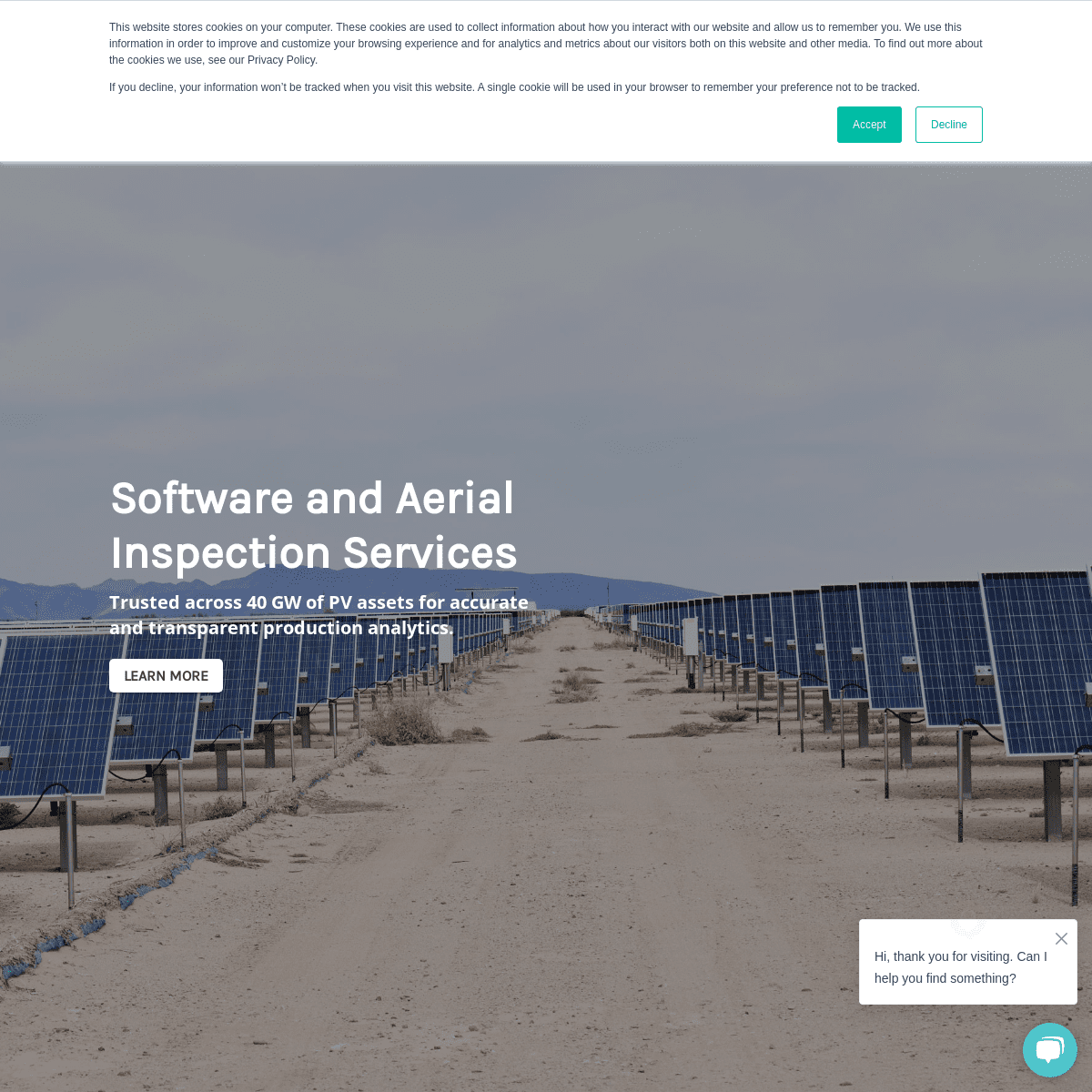
SOFTWARE AND AERIAL INSPECTION SERVICES Trusted across 40 GW of PV assets for accurate and transparent production analytics.Learn More
FIND AND REMEDIATE ANOMALIES FASTER AND START OPTIMIZING SOLAR ASSETS IN A WHOLE NEW WAY WITH YOUR RAPTOR MAPS MOBILE APP.Learn More
RAPTOR MAPS SUPPORTS THE ENTIRE SOLAR STACK SOLAR PV CONSTRUCTION PV CONSTRUCTION VERIFICATION THE SATELLITE CONSTRUCTION VERIFICATION SOLUTION ENABLES YOU TO REMOTELY MONITOR, AND VERIFY THE PROGRESS OF CONSTRUCTION PROJECTS. IDENTIFY PROBLEMS IN ADVANCE AND MEET DEADLINES.LEARN MORE.
ROOFTOP PV PLANNING SURVEY THE ROOFTOP PV PLANNING SURVEY ENABLES TEAMS TO DESIGN THE SITE RIGHT THE FIRST TIME TO PREVENT UNEXPECTED COSTS, REDUCE RISK, AND BEGIN OBTAINING NECESSARY PERMITS.LEARN MORE.
AERIAL TOPOGRAPHIC SURVEY THE AERIAL TOPOGRAPHIC SURVEY EQUIPS TEAMS WITH THE SITE ASSESSMENT DATA, FACILITATING PROPER INSTALLATION PLANNING TO ENSURE SWIFT CONSTRUCTION AND PREVENTING UNEXPECTED ISSUES LATER ON.LEARN MORE.
ENERGIZED PV ASSETS
AERIAL THERMAL INSPECTION AND ANALYTICS THE RAPTOR MAPS SOLAR ASSET INSPECTION TOOL DELIVERS ANALYTICS AND EASY-TO-USE REPORTS THAT ENABLE TEAMS TO INCREASE POWER PRODUCTION, REDUCE RISKS, AND LOWER OPERATING COSTS OVER TIME.LEARN MORE.
AERIAL SHADING INSPECTION AND ANALYTICS AN AERIAL INSPECTION OF THE TREES AND OBSTRUCTIONS CAUSING SHADE ON A SOLAR PV SYSTEM. REMOTELY IDENTIFY, LOCATE, AND VISUALIZE OBSTRUCTIONS DECREASING PV SYSTEM PERFORMANCE.LEARN MORE.
WE ENABLE YOU TO COLLECT AERIAL SOLAR DATA AND GAIN COMPREHENSIVE ANALYTICS AND ACTIONABLE REPORTS TO OPTIMIZE YOUR ASSETS.STEP 1
AERIAL INSPECTION
By in-house inspection or turnkey serviceSTEP 2
ANALYZE DATA
With industry-leading machine learningSTEP 3
ISSUE LOCALIZATION
QA checked by designated specialistsTHE RESULT
IN-DEPTH REPORTS
Delivered on a cloud-based platform BEGIN OPTIMIZING YOUR SOLAR PV ASSETS THROUGH: GLOBAL TURNKEY SERVICES Raptor Maps will handle the aerial thermography inspection through our global drone service partner network, analyze the data, and send you acomplete report.
LEARN MORE
INTERNAL INSPECTION SUPPORT Perform the inspection with your in-house drone program and send the data to Raptor Maps. We’ll send you an in-depth report on the operating condition of the PV system.LEARN MORE
GW OF SOLAR PV ANALYZED UTILITY-SCALE AND C&I SYSTEMS INSPECTED OF ANNUAL ROI PER MW COUNTRIES IN ACTIVE SERVICE “The partnership with Raptor Maps on this innovative technology goes beyond demonstrations, and implements ground-breaking solutions in a responsible and scalable way.” > Rafael Gonzalez, Head of ENEL GREEN POWER NORTH AMERICA “Aerial thermography has become a valuable tool in SOLV’s offering as a solar O&M provider to maximize DC health. The ability to perform these inspections internally makes us more efficient and allows us to scale operations, passing those savings on to our clients. A major challenge of aerial thermography is how to process and generate reports once a site has been inspected. SOLV evaluated a dozen companies that provide drone inspection imagery data processing and report generation and found Raptor Maps to be the best solution in the market for our specific needs. Raptor Maps enables us to quickly and effectively perform the drone inspection, can support our wide range of sites under management, and provides clear and actionable reports for our field team on what items need to be fixed versus monitored,” > Reegan Moen, Business Development Manager, SOLV, INC., A SWINERTON> COMPANY
“The Raptor Maps team has developed a solution that has added excellent value to Cypress Creek O&M. This partnership allows our Reliability Engineering team to focus on inspections, repairs and analysis and leave the heavy lifting of reviewing thousands of images for anomalies to automation without measurable impacts to accuracy. The partnership will lead to improved report turnaround time, more time devoted to inspections and repairs and most importantly improved facility performance for our customers.” > Kyle Cooper, VP of O&M, CYPRESS CREEK RENEWABLES “New Energy Equity, the country’s leading end-to-end solar development and finance specialist, and its asset management division, Energy Support Services, which brings a proactive and data-driven approach to solar asset management, chose to add Raptor Maps’ aerial inspection services and solar analytics software to our workflows to increase efficiency and collaboration between our teams. Raptor Maps enabled us to reduce our use of exploratory IV curve tracing, significantly lowering our operating costs. The transparent software platform helps us efficiently manage our assets, identify DC health issues earlier, and provide best-in-class O&M services to our clients who also have access to the platform.” > Conrad Gross, Director Operations, ENERGY SUPPORT SERVICES, NEW> ENERGY EQUITY
PreviousNext
FEATURED CONTENT:
Global benchmarking for the solar PV industry: 2021 GLOBAL SOLAR AERIAL INSPECTION REPORT.Download
Industry white paper: SOLAR PV INDUSTRY INSPECTION METHODS COMPARISON: AERIAL THERMOGRAPHY VS I-V CURVE TRACING.Download
LET’S CONNECT!
We work with Asset Owners, EPCs, Asset Management, OEMs, and O&M teams who are looking to improve the efficiency of their solar assets during any stage of its lifecycle. Contact us to learn how our software will enable you to scale.get started
Privacy Policy
Terms of Service
* Follow
* Follow
* Follow
� 2021 Raptor Maps, Inc.info@raptormaps.com
444 Somerville Ave.
Somerville, MA 02143Raptor App Login
Details
2